A suggested walk on Hankley Common
Most birders in Surrey are familiar with Thursley Common, and with Frensham Common and Ponds to the west. But fewer are familiar with Hankley Common, which lies between the two, and to the south-west of the village of Elstead.
Hankley Common is designated as an SSSI (Site of Special Scientific Interest) and comprises a large area of lowland heath, woodland and rank grassland. It is owned by the Ministry of Defence and is used for military exercises. For the most part there are no restrictions on access.
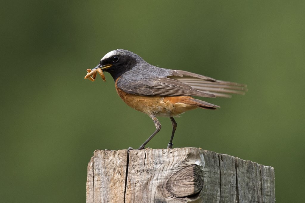
The birds are typical of a mixed heathland and woodland habitat. Dartford Warblers are common after mild winters. Woodlarks are scattered across the common, as are Nightjars. It is a good location for Tree Pipit, and it is one of the few remaining sites in Surrey for breeding Meadow Pipit. Other breeding species include Stonechat, Redstart, Common Whitethroat, Linnet and Skylark, while it is worth keeping an ear open for Crossbill, particularly if it is a Crossbill year. Surprisingly, Hobbies are not often seen on Hankley, possibly because there are few dragonflies.
The common is large – about 4km north to south, and 2km east to west. It consists of a northern third which includes a golf course and is dominated by Yagden Hill; a central bowl which contains some army huts and the area of rank grassland; and a southern bowl which has extensive areas of good quality heathland.
Like lowland heaths generally, Hankley Common is fairly birdless in winter. The best time to visit is between about mid-March, when Woodlarks move back onto the common and start singing, and September, before most birds move off. It is too large to cover in a single visit, so this suggested walk concentrates on the central bowl, while giving good views over the southern bowl.
The walk
The main car park is reached up a metalled road with potholes which runs west off a sharp left hand bend on the road running south from Elstead, about a mile and a half south of the village. The map reference is SU 891411. If the car park is closed, there is parking along the approach road. The area to the south of the car park is a good area to look for Nightjars on a warm June evening without venturing too far on to the common. They sometimes perch on the electricity wires.
From the car park take a main track heading south, following the line of pylons and keeping a ridge on your right. After about two-thirds of a mile turn right at the base of pylon 25 onto a narrow track. This brings you to a main track running down from the end of the ridge, and you turn left onto this track. This is a good area for Dartford Warblers. Keep straight ahead at a point where 5 tracks cross (point ‘X’ on the map) and straight ahead again when the main track around the bowl bends off to the right, going up a steep hill bordering a wood on your left until you reach the highest point – an obvious small conical hill. There are panoramic views from the top of this hill.
Turn right on the hill and take the track running west along the ridge, which gives you good views of the southern bowl on your left. The area around the ridge holds breeding Dartford Warbler, Linnet, Stonechat and Nightjar. When you arrive at a large area of woodland in front of you and running away to the right, turn right down a short hill. Redstarts can usually be found in this area.
Turn right again at the bottom of this short hill, going anti-clockwise along the main track around the central bowl. After about half a mile this track rejoin your outwards route, where you turn left and briefly retrace your route to the crossing of five tracks (point ‘X’). Take the first left here on a path that runs diagonally across the bowl. This takes you through an area of damp grassland where Meadow Pipit and Skylark breed.
When you reach the main track round the bowl again turn right, and after about 400 yards take a wide path to the left which climbs a ridge. This is a good area for Woodlark. Keep right as you go up the hill, turning right onto the track running along the ridge. This drops down into a narrow gap in the ridge known as the Lion’s Mouth. The track splits into two and you can take either of the two narrow tracks (which are quite steep). Turn right at the bottom (point ‘Y’) unless you want to visit the Atlantic Wall (described later) through woodland, listening out for Redstart and Willow Warbler. Keep right when the track bears right and ignore the path off to the left. After two or three hundred yards a metalled road comes in from your right – from the army huts – so turn left onto the road which goes up the hill in front of you. This road will take you back to the car park.
This walk is 6 km long. If that is too long, simply leave out the loop from point ‘X’ and take the diagonal path across the bowl. That will save you 2km and two short steep climbs, but you’ll miss the views.
Other information
A noteworthy feature of Hankley Common is a crumbling concrete wall which was constructed as a replica of the Atlantic Wall and used by Canadian troops in training for D-Day. In its decayed state the wall provides an alkaline habitat in a generally acidic environment, and it is home to some plants which are scarce in this part of Surrey.
If you want to see the ‘Atlantic Wall’ turn left at point ‘Y’. Paths go off in various directions here but just keep straight on for a couple of hundred yards and you will then see the Wall on your left. After visiting the Wall, return to point ‘Y’.
Hankley Common is sometimes used as a filming location and was the location for the final, climactic scenes in Skyfall. So as well as some interesting birds, you may run across an early mediaeval Scottish village (Macbeth) or heaven knows what.
If you sometimes use a stick when walking, it might be sensible to take one with you.